Kakadu National Park – Overview & Things to See and Do
Overview
Internationally recognised, Kakadu is a World Heritage listed area that covers 19,000 square kilometres. Extensively marketed, it is exceptional because it qualifies for World Heritage listing on the basis of both natural and cultural criteria.
Geographically the park has five major topographical landforms. Kakadu covers a huge region with vast floodplains hundreds of kilometres of escarpments, estuaries, lowlands & monsoon rainforest. Aboriginal culture abounds throughout the Park with some 5000 sites recorded. To quantify with statistics; Kakadu has 1,600 plant species, 275 bird species, 75 reptile families, 25 frog species 55 species of fish and an amazing 10,000 species of insects.
Made popular by strong marketing and the movie Crocodile Dundee, the park has been known to be a disappointment to visitors whose expectations haven’t matched their preparation. Make sure you know what to expect before arriving. It must be stressed it is a difficult place to appreciate in a short visit and while it is as beautiful as the claims experiencing that beauty requires some planning. Kakadu is NOT a day trip from Darwin. To fully explore this Park you need to travel off the main road. If you were to travel straight through the national park on the main Arnhem and Kakadu Highways you would leave with a poor impression.
Fuel & Supplies For more information click here
Accommodation For more information click here
When to visit
The climatic conditions and landscape change dramatically between the seasons. Seasonal changes mean that your experience in Kakadu will vary according to the time you visit.
Dry season (May to September) is when humidity and temperatures are at their lowest. Most visitors prefer the mild conditions that make it an enjoyable time to explore and roads are open.
Wet season (November to March) is when humidity combined with high temperatures makes it uncomfortable. However, if you can cope with the heat it is the best time to see the Park. Some areas however are closed due to wet season flooding.
“Build-up” (usually October, November) is very hot and humid with little to no rain. Although compensated by dramatic electrical storms, it’s best to limit your outdoor activities to early morning & late afternoon. It is also the best time to view crocodiles and birds on the rivers and wetlands. Dry season itineraries apply.
Visitors prefer to come here during the cooler months of the Dry. However by the end of the Dry, some of the park’s most spectacular waterfalls including Jim Jim and Twin Falls, generally do not carry water. The rock formations are still worth seeing, but the raging torrent of water that makes the falls such an incredible site are missing.
To see Kakadu during the Wet or the early Dry is to see it at its best.
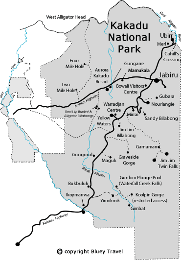
Things to See & Do by Region:
Nth Entrance & Sth Alligator Region
Two Mile Hole & Four Mile Hole
Designated camping areas besides two billabongs that have abundant wildlife especially late in the dry season.
Waldak Irrmbal (West Alligator Head)
If you travel 42 km north of Four Mile Hole you will reach the coast and 2 remote camping areas: namely Pokok’s Beach, which has toilets; and Middle Beach, which has no facilities. The Pristine coastline offers a picturesque spot to relax and get away from the crowds but only suited to the well prepared. Please Note: Seasonal Access restrictions apply.
Gungarre Monsoon walk
Gungarre Monsoon forest and billabong walk takes you through a monsoon forest, along the edge of a billabong and finally through fringing woodlands. View plant life and Aboriginal use of plants from the three habitats, monsoonal vine forest, floodplain and woodland. The walk is open all year round, is 4.3km loop and takes up to 1.5 hours.
Mamukala Wetlands
Mamukala is a wetlands observation platform with well presented information. Beautiful all year round, it is at its most dramatic in the late Dry Season, when thousands of Magpie Geese congregate to feed. Choose from a short walk to the observation shelter or a 3km loop walk to see more of the wetlands. Open all year round, entry is free.
Bowali Visitor Centre
This excellent (both in design and content) information centre displays information from both the Gukburlerri (Aboriginal) and Guhbele (non-Aboriginal perspective). Information includes audio visual displays, park notes and the latest information on ranger lead walks at many of the sites. Translations are in four languages. The complex includes a café and gift shop.
Bowali Visitor Centre should not be missed. Open: Daily 8am to 5pm. Phone: (08) 8938 1120. Admission is free.
East Alligator Region
East Alligator River
An attractive stretch of river, the East Alligator River forms the boundary between Kakadu and Arnhem Land. A commercial boat cruise is available, and a boat ramp is located both upstream and downstream of the crossing. Cruising along this stretch of river is one of the highlights of a visit to Kakadu yet little known by mainstream tourists.
Cahills Crossing
A popular croc watching and land based fishing spot, Cahills Crossing is a concrete causeway and the only road access point into Arnhemland. Crossing the East Alligator River at Cahills crossing is not permitted unless you have a permit. (See Northern Land Council 08 8979 2410). If you do have a Permit, be very careful crossing this river. Despite the signs warning of the danger including photos, every year vehicles get washed away. The river is tidal so a few hours wait can save you much heartache. Check with border store regarding the tides. The whole region is only accessible during the dry because the Magela Creek floods the road on the way in.
Guluyambi Aboriginal Culture Cruise
This cruise gives visitors the opportunity to see the spectacular escarpment and rock paintings at Arnhemland’s edge. Guides on the cruise are local aboriginal people who explain some of the local customs. The cruise gives you a chance to set foot, albeit briefly, on Arnhemland. You are certain to see crocodiles on this cruise. Bookings recommended. A recommended attraction.
Allow: 90 mins Phone: 1800 089 113
Ubirr
The rock-galleries at Ubirr are one of the world’s best known collections of ancient art. The paintings illustrate the rich food resources of the wetlands. Fish, lizards and marsupials including the now extinct Tasmanian Tiger. The Lookout offers a beautiful view across the East Alligator wetland especially at Sunset. Ranger talks usually correspond with the sunset and bus tour operators are encouraged not to visit at this time. A recommended attraction and a recommended time to visit. Bill Neidjie one of the most famous Aboriginal people in Kakadu lives in this area and occasionally comes up to the rock
Open: 8.30 am – Sunset (1st May – 30th Nov)
2.00 pm – Sunset (1st Dec – 30th Apr)
Allow: 1 hr (2 hrs at sunset)
Bushwalking Around East Alligator Region
Four walking tracks ranging from the easy 1 km walk at Ubirr to a 8 km trip that takes approximately 3 hrs return through escarpment along the East Alligator River. For a summary of the walks refer to our travel guide. The 1 hr Bardedjilidji walk leads to the rocky outcrops of Arnhemland and is one of Kakadu’s best short walks. A recommended attraction. Don’t forget water and sun protection.
Nourlangie District
Nourlangie Rock
Kakadu’s most accessible and therefore most visited site. It includes the Anbangbang Rock Shelter, where there is evidence of occupation stretching back twenty thousand years. The Anbangbang Gallery, nearby, depicts the dramatic figures of Nabulwinjbulwinj, Namarrgon (the Lightning Man) and his wife Barrkinj. A 1.5 km circular walk will take you past an ancient Aboriginal shelter and several outstanding art sites. There is also a moderately steep climb to Gunwarddehwardde lookout, which provides impressive views of Kakadu’s escarpment and Nourlangie Rock.
Open 7.30am to 5.00pm daily all year round, Cost: entry is free. Rangers conduct guided talks of the area
Anbangbang Billabong,
Anbangbang Billabong is nearby with a picnic site and dense carpet of lilies. Anbangbang Billabong Walk is a 2.5km circular walk that is only open in the dry season.
Nanguluwar Art Site
This art site is a flat 4 km, 1.5 hr return walk from the Nanguluwar carpark. The fact that the access road is very corrugated and doesn’t get tour buses means the art site sees fewer visitors. Nanguluwur includes images from the Contact period when Aborigines first encountered explorers and settlers.
Nawulandja Lookout
Nawulandja Lookout looks onto the imposing hulk of Nourlangie Rock itself, which looms over Anbangbang Billabong. Great place for sunset.
Gubara
Gubara or Burdulba Springs, an unsealed 13 km off the Nourlangie road, is a string of small pools along a palm-shaded creek, itself a hot 2 hr return walk from the car park.
Warradjan Aboriginal Cultural Centre
Like the Bowali Information Centre, this centre was refit by the Australian Nature Conservation Agency. The centre was constructed to give insight into the culture of the park’s traditional owners. The building itself is circular, which is a symbol for the way the Aboriginal people sit in a circle when having a meeting. The shape is also reminiscent of the warradjan (pig nosed turtle) hence the name. Inside, the displays depict creation stories when the first people laid out the land and the laws. Signs invite the visitor to move through the display, as a Rainbow Serpent (creation ancestor) moves through the country.
Its an excellent display, with crafts made by the local people as well as audio visual displays. There is also a craft shop selling locally made items such as didgeridoos and T-shirts. Open: daily from 8.30am – 5pm, Cost: entry is free.
Yellow Waters
Yellow Water Billabong lies 6.5 km off the Kakadu Highway near Cooinda. A pristine environment which supports a wonderful variety of plants, birds and animals. Boardwalks and cruises (either 1.5 hrs or 2 hrs) are very popular providing great views of the abounding wildlife.
Open daily, however check for boardwalk access, and entry is free.
- Yellow Water Cruises
From the car park here, a short walk leads along the edge of the billabong, from where popular cruises (five daily; book in advance on 08/8979 0145). The early-morning cruise (2 hr) catches the lagoon and wildlife at their best: heat-of-the-day tours are thirty minutes shorter and a few dollars cheaper.
Jim Jim & Southern Region
Bilbilkimbi – Graveside Gorge (4×4)
A beautiful and remote part of the park that is accessed via a difficult 4WD track. Offering attractive crystal clear waterholes upstream, This is a very remote and pristine area and much of the walking is “cross-country”. You can spend all day exploring with plenty of opportunity for bird watching, photography or simply relaxing in this peaceful wilderness area. The area is best explored by camping and bushwalking over a couple of days but makes a good day trip. (Always check with the Visitors centre regarding safe places to swim!! )
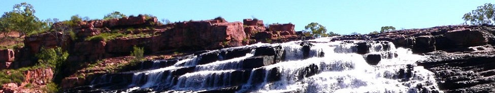
Gunlom Plunge Pool (Waterfall Creek Falls)
Not as well known as Jim Jim and Twin Falls but Gunlom is well worth the visit. A serene waterfall and plunge pool. Has camping facilities, fresh water, toilets and a picnic area with fireplace.The falls don’t flow all year round, the flat land below the escarpment leads to a billabong and creek. Neither can be swum in because of the risk of crocodiles. The park rangers clear the crocodiles out of the main plunge pool at the end of the wet so that it can be used for swimming. (Always check with the Visitors centre regarding safe places to swim!! ) There is a steep path to the top of the falls revealing more plunge pools and a spectacular view of the Arnhemland Escarpment.
Open: From April to November,
Cost: Entry is free but camping fees apply.
Guratba (Coronation Hill)
A picnic site on the South Alligator River, this is the site of a former uranium mine. To local Jawoyn Aborigines this area is traditionally “Sickness Country”, suggesting that even in its natural state uranium proved harmful to human health.
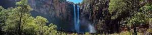
Jim Jim & Twin Falls (4×4)
These two falls are the most advertised in the Top End and are worth visiting; Access to both falls is off the Kakadu Hwy along a 4WD only road. The last 10 km to the Jim Jim campsite is slow sand. A further 10 km of 4WD track takes you out to Twin Falls – but first you must cross the Jim Jim Creek. a guided crossing between white posts is available but check water level before crossing (Refer to section on creek crossings – markers should not always be taken as gospel) Allow two hours driving time one way to Jim Jim a further 3/4 hrs to
Twin Falls.
Jim Jim Falls cascades over 200m straight off the edge of the escarpment and are best visited in the early Dry, as soon as the road reopens – as they often stop flowing later in the season and will certainly look less impressive. A rocky, one-kilometre trail leads alongside the large pool to the base of the falls.
Twin Falls is a rough ten-kilometre drive from Jim Jim, including the crossing of Jim Jim Creek. From the car park it’s a short walk and then a swim up the monsoon-forested gorge for another kilometre – an airbed and waterproof containers help here. This little bit of adventure is rewarded by the sight of Twin Falls cascading into a pool edged by an idyllic sandy beach, a beautiful and recently very popular spot to while away the day. The sure-footed can scramble to the top of the falls via the overgrown gully to the right – a difficult climb capped with a view you won’t forget in a hurry, but please note that fatal accidents have occurred here. Both falls quickly become inaccessible after the first big rains.
During the dry the rock formations are still worth seeing, but the spouting, raging, foaming torrent of water that makes the falls such a wonderful sight is often missing.Open for 4WD access only from June to November, entry is free.
Koolpin Gorge (4×4)
A beautiful gorge, but access is limited to keep it in its pristine wilderness state. The creek flows down several hundred feet. A permit and entry key must be organised in advance. Open for 4WD access only from May to November, a deposit for the entry key is required. The key is available from the Southern Entry Station on the Pine Creek road where you must leave a $50 deposit. The track to the gorge is a challenging 4WD track, ending just before the actual gorge which begins 1km upstream and continues deep into the escarpment. You can camp here or follow the escarpment on foot to the northwest for 3 km to the narrow chasm of Freezing Gorge which, you’ll be pleased to discover, lives up to its name.
Maguk (Barramundi Gorge) (4×4)
Maguk is a small yet spectacular waterfall and clear plunge pool 2 km walk from the car park through monsoon forest. Considered to be the best of Kakadu’s few swimming holes and well worth the trip time permitting.
Several picturesque picnic areas can be found in this area, as well as other smaller plunge pools and waterfalls set in monsoonal forest.
It is 12 km off the Kakadu Hwy along a corrugated 4WD track. Driven carefully, robust 2WD cars can manage the twelve-kilometre corrugated track albeit very slowly.Cost entry is free.
The top of the waterfall and more rock pools can be reached by clambering up the tree roots to the right of the falls.
Old Darwin Road
The Old Darwin Road (or Jim Jim Road), unsealed, but usually passable for robust 2WD-cars in dry conditions, is a good alternative to slogging the full length of the Arnhem Highway to get to Cooinda and on to Jim Jim and Twin Falls. It starts 12 km east of the Bark Hut Inn on the Arnhem Highway and joins the Kakadu Highway near Cooinda, 100km further on.
Tours:
Scenic Flights
Kakadu Air (phone: 1800 089 113) operates out of the airport at Jabiru East offering one-hour scenic flights along the escarpment and wetlands . Scenic flights depart regularly or on request from Cooinda Airstrip. Many of the spectacular features of the park and the vastness of its landscapes can only be fully appreciated from the air. This is especially true in the wet season when road access to some areas are restricted and highlights such as Jim Jim and Twin Falls are in full flow. In case you are wondering, landing of planes or helicopters other than at licensed aerodromes (including food drops or the positioning of walkers) is not being allowed.
Boat tours
Tours depart regularly from Yellow Water and the East Alligator River. Bookings are required and is one of the best ways to see the park. Refer specific information under these locations.
Jim Jim Twin Falls Tour
Guided Tours to Jim Jim and Twin Falls, are available for people who don’t have a 4WD or have hired a 4WD but car rental terms and conditions don’t allow access into Jim Jim and Twin Falls. Tour Guides can collect you from either Jabiru at 0645 or Cooinda at 0730. As you leave the highway you travel through the savannah woodlands of Kakadu. Along the way your guide will talk to you about the park and explain the bushtucker, the local Aboriginal culture and some history of the area.
Arnhemland Tour
Guided tours into Arnhemland only depart Jabiru. After collection from your Jabiru accommodation you are taken up towards Ubirr where you will cross the East Alligator River at Cahills Crossing into Arnhemland. At the invitation of the traditional owners the tour accesses areas of Arnhemland including the stunning escarpments and floodplains of the Mikinj Valley. Excellent examples of rock art at Injalak Hill and a visit to the award winning Injalak Art & Craft Centre at Oenpelli are part of this popular day tour.
Animal Tracks Safari
Departing Cooinda at 1pm this tour offers an authentic wilderness experience participating in various aspects of aboriginal culture incl traditional hunting and gathering and an aboriginal campfire bush food cook-up during sunset. The tour is run by traditional local aboriginal guides and accesses a 170 sq. km. reserve that is the exclusive domain of this tour.
Other Information
Aboriginal Land
Much of Kakadu is aboriginal land leased back for use as a National Park. The Park is jointly managed by the Australian Nature Conservation Agency and the traditional owners, 10 of whom sit on the 14 member board of management. The traditional owners still live on the land and are keen to preserve their history and sacred sites for future generations of both Aboriginal and non Aboriginal people. About 1/3 of the park’s rangers are Aboriginal.
Today, three major languages are spoken within the park – Gundjeihmi / Mayali, Kunwinjku and Jawoyn.
Ancient Rock Art
Aboriginal culture abounds throughout the Park with some 5000 sites recorded. Kakadu is another way of saying Gagadju, one of the main language groups in the area. Dating of rock art indicates that Aboriginals have been here for over 50,000 years making it one of the oldest recorded continuous occupation of a region by human beings.
The rock art at Kakadu is the most significant example of prehistoric art in the world. Ubirr Rock and Nourlangie Rock are the best-known art sites in the park. As you can appreciate, there is significant rock art throughout the park and into Arnhemland. Most of them are inaccessible to visitors, because many are still of spiritual significance to the three hundred Gagudju and other language groups who live in the park.Overnight treks with guided tours are available to some art sites that have been given special clearance by the traditional owners. To visit the truly spectacular areas you will need to take a tour with dedicated lease people.
Jabiru Township
Jabiru is modelled on suburban Canberra and built in 1982 before the park was established, to service the workers and families of the proposed Uranium Mines at the time. Jabiru is a full service town with Post Office, Bank, Supermarket and Service Station as well as sporting club and community Pool.
Extended Bushwalks:
Experienced bushwalkers can apply to Park HQ with proposed itineraries, which need to be approved before a permit is given. Specific popular walks have been approved by traditional owners and generally permits are issued for these areas and denied for other areas. Allow seven days for processing permits. Operators in Darwin organise extended bushwalks up in the escarpment.