Uluru (Ayers Rock) – Overview & Things to See and Do
About 450 kilometres by road from Alice Springs, Uluru-Kata Tjuta National Park is home to the most recognised Australian landmark – Uluru (previously called Ayers Rock). World-Heritage listed, Uluru – Kata Tjuta National Park covers an area of approximately 1325 square kilometres of striking landscape. In addition to the Rock the park also includes Kata Tjuta (previously called the Olgas). It is administered by the Australian Nature Conservation Agency on behalf of the traditional Pitjantjatjara and Yankuntjatjara owners, some of whom live in the small Mutitjulu community at the base of Uluru. The traditional owners collectively call themselves Anangu, and would like you to use that term.
Most visitors would have seen photographs, illustrations, television documentaries or advertisements featuring Uluru, but nothing prepares you for the physical impact of the vast monolith. Its sheer immensity dwarfs everything around it. Uluru is some 9 kilometres in circumference and it rises approximately 400 metres above the surrounding plain (900 metres above sea level).
Uluru has acquired its reputation not just because it is such a unique landform, but also because of the effect the sun has on its colours and appearance. Sunrises and Sunsets cause changes to its colour from browns though oranges, reds to finally grey. The best colour effects occur on overcast days. Additionally the sun casts shadows off the larger and smaller gaps on the rock face which incredibly changes its look almost by the minute.

Climate
The climate in this region is extreme. In winter, daytime temperatures can be pleasant but clear nights regularly see the temperature drop below 0. In summer on the other hand, the temperature can get very hot peaking as high as 45C. Normally its around 30 -35C. Climbing the rock is prohibited between 8.00 am and 4.00 pm if the temperature is forecast to be hotter than 38
The highest temperature recorded at Uluru was 45.5 degrees Celsius on 17 February 1992.
In 1997 it actually snowed on Uluru
Access & Climbing the Rock
The park is opened from 5 a.m but the climb to the top does not open until sunrise for safety reasons. Also for safety reasons, the Uluru ascent may be closed at 8 a.m in days of extreme heat.
Uluru can be climbed at its North-Western end, although traditional owners prefer that people not climb the Rock. Uluru is not an easy climb and people with heart and respiratory problems or fear of heights should not attempt it. If you visit the Cultural Centre you will learn more about the significance of Uluru in Anangu law and culture. The local people request you do this before you decide whether to climb. There are many other activities and walks available in the park. While the views from the top of Uluru are spectacular, scenic flights are a realistic alternative.
The steepest section has a chain on it and is very steep. After the chain ends, it becomes windy. The walking distance to the top is about 1.6 kilometers but is hard to judge because you cannot see the whole path at any one time.
Safety
Please consider your fitness before undertaking activities in the Park.
Heat Stress: Summer days are extremely hot. Remember to carry and drink plenty of water where ever you go in the Park and rest in the shade. A brochure on Safety and Comfort is available at the Cultural Centre. Please read this carefully.
Remember to:
Wear a hat, strong shoes and sunscreen.
Carry and drink at least 1 litre of water per hour.
Walk in the cooler parts of the day.
Stay on the tracks.
Do not attempt to climb Uluru if you suffer from: Heart Condition Breathing Difficulties or Fear of Heights
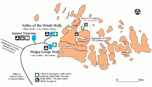
Park Rangers can be contacted at any time by using any of the six emergency radio alarms located at: Mala Walk carpark at the base of the Uluru (Ayers Rock) Climb; The Valley of the Winds carpark at Kata Tjuta (The Olgas); The emergency water tank on the ‘T’ intersection on the Valley of the Winds walk at Kata Tjuta; Walpa Gorge carpark at Kata Tjuta; Kuniya Piti carpark at the eastern end of Uluru; Kata Tjuta dune viewing area.
Things to See & Do
Cultural Centre: Visit the Cultural Centre first. You will enjoy exploring the Park much more if you know a little about Anangu culture and this semi-arid environment. Displays at the Cultural Centre are in Pitjantjatjara, English, Italian, Japanese, German and French. The Culture Centre features Aboriginal arts, displays, video and demonstrations that explain the history and significant culture of this land.
Access & Climbing the rock: The Uluru climb is the traditional route taken by ancestral Mala men upon their arrival to Uluru. Anangu do not climb Uluru because of its great spiritual significance. While Anangu have not closed the climb. They prefer that you – out of education and understanding – choose to respect their law and culture by not climbing. Remember that you are a guest on Anangu land.
Scenic Flights: By fixed wing or helicopter, the aerial view puts the size of Uluru and The Olgas into perspective against the flat desert. A number of different flights are available ranging in duration from 15mins to 2.5hrs depending on how much of the surrounding region you want to explore.
Sounds of Silence: A runaway success since its launch, sounds of silence is a fine dinning diner out under the stars. Overlooking the rock, the dinner lasts for 3 hrs beginning around sunset and is a must do experience. Pre booking essential. Depending on time of year nights can get very cold so be prepared and have suitable clothing.
Camel Tour: Opportunity to ride a camel through the red sand dunes to an observation deck were you will watch the sun rise over Uluru and the brilliant range of colours it creates. Tours throught the day and sunset tours are also available if you prefer to sleep in.
Harley Davidson Bike Tour: Opportunity to Let one of Uluru Motorcycle Tours expert riders show you the wonders of the Uluru/Kata Tjuta National Park, on the back of a Harley-Davidson motorcycle.
Sunrise and Sunset Viewing: Watching the colour of Uluru and Kata Tjuta change is a spectacular and popular activity. The colour changes result from the effects of the Earth’s atmosphere on the sun’s incoming rays. The ash, dust particles and water vapour present in the earth’s atmosphere act as a filter which can remove the bluer light from the incoming rays of the sun, allowing the redder light through at different times of day. Reflections from the rock and clouds in the sky enhance the vivid colours.
There are specific parking areas constructed at the best locations to view and photograph the sunrise and sunset at Uluru and Kata Tjuta. The best time to see Uluru is at sunrise. At sunset, the more convenient time, there are literally hundreds of people all jockeying for position in the sunset viewing area.
Walking Tracks
Longer Walks:
- Base of Uluru (10.6km / 3-4hrs full circuit) This track goes around Uluru. It is an excellent alternative to the Climb. The walk is quiet and you are unlikely to encounter large groups of people in most areas. Walk in a clockwise direction. It takes in the Mala and Mutitjulu walks along the way.
- Valley of the Winds – Kata Tjuta (7.4km / 3 hrs full circuit)This is your opportunity to walk in the spectacular landscape of Kata Tjuta. Excellent views can be enjoyed from two lookout points along the track. Please beware that the walk is steep, rocky and difficult in places.For your safety, this walk is closed from Karu Lookout at 11.00am if the forecast temperature is 36º or greater.
Shorter Walks:
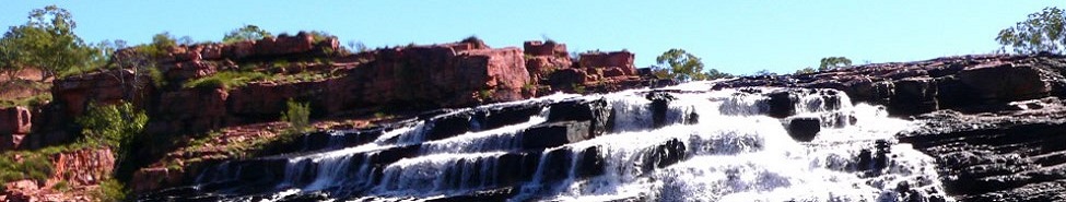
- Walpa Gorge – Kata Tjuta (2.6km / 1 hr return) Takes you to the end of the Gorge where Spearwood vines flourish. The track gently rises as you go giving a good view of the surrounding country to the west.
- Mutitjulu – Southern side of Uluru (1km / 45mins return) Takes you to a beautiful waterhole past rock art sites. In this area you will see evidence of the battle between Kuniya (woma python) and Liru (poisonous snake man). Available as a self-guided walk.
- Mala – North-West side of Uluru (2km / 1hr return) Takes you to the inspiring Kantju Gorge past several caves used by Anangu not so long ago. Available as a self-guided walk.
- Dune Walk – Bus sunset carpark (30 mins return) Takes you along a sand dune with views of both Uluru and Kata Tjuta. Look for animal tracks, compare sand dune vegetation with the woodland stretching towards Kata Tjuta.Anangu Tours – Kuniya and Liru Walks.
- The The Liru Walk is the equal second-longest walk, running for four kilometres from the Cultural Centre to the base of Uluru. It takes about 1 hour, 30 minutes and offers a great look at the native flora and fauna along the way. The track winds through stands of wanari (mulga) and after rain, often displays colourful flowers.
Guided tour with Anangu Guides: In addition to a sealed road around the base of the rock there is a marked walking track. You can chose to do it on your own or with an Aboriginal guide (extra cost) who can explain the dreamtime stories and plant life from Aboriginal perspective. Some significant ceremonial places at Uluru and Kata Tjuta have been declared out of bounds for visitors.
Ranger Guided Walk: A free Ranger guided Mala Walk is conducted daily from the base of Uluru. It starts at 8:00am October through to April and 10:00am during May through to September. Allow 1.5 hours. This walk is wheelchair accessible. A Ranger will guide you along a shaded track, stopping to discuss Tjukurpa (Aboriginal law) stories associated with Mala ancestors, joint management, rock art, traditional Anangu lifestyle, history and the environment.
Kata Tjuta (The Olgas): The Olgas are a collection of weathered red domes, located 50 km from Ayers Rock along a sealed road. Many people consider them to be as spectacular as the Rock. There are two bushwalks Valley of the Winds 7.4km circuit 3 hrs and Olga Gorge 2.6km 1 hr both recommended.